|
| |


| |
|
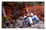
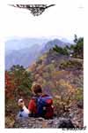
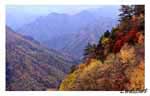
The difficulty of this hike makes it very interesting. It's not a simple walk in the woods especially as you get closer to the top. The last 2 kilometres involve a lot of rock climbing. It's not an easy trail and it isn't hard to go down as the path is very narrow with sudden falls on both sides where the trail follows top of the mountain ridge. There are huge rocks sticking out of the ground that have to be climbed. Vertical walls of 10 metrres in height are common. Fortunately, in places like that chains are attached to the rocks to make climbing possible for anyone. Views are breathtaking. We went there in October when the leaf foliage was at its best. At some points the peak of Mt. Fuji can be seen. The first stage is in the thick forest and the path follows a stream for a while. The second stage is also in the forest, but not so thick anymore making it seem very spacious. The views begin when the trail reaches top of the range. Unfortunately, we never reached the top. It is necessary to start the hike in th eearly morning to reach the top of Mt. Ryogami and back. We started around noon and were forced to turn around at about 3 o'clock. We were 1100 metres from the top and it would've taken us another 2 hours climbing all the rocks that seemed to be bigger and bigger the closer we got to the top. The last 2 kilometres are the most dangerous and walking it at night without a flashlight could've been fatal. We didn't have a tent either to spend the night there, and so we turned around very satisfied nevertheless. A month later a man became missing on the trail and hasn't been found since. I also found out from teachers at my school that every year people go missing there. We're going to try again in the spring. Maybe then we'll be more lucky and reach the top. mt. ryokami - the top (aug. '04)In October 2003 when the leaves of Japanese maple trees turn red, yellow and orange we tried to climb Mt. Ryogami in Saitama prefecture. We planned to reach the top and return on the same day, but we underestimated the difficulty of climbing that mountain and were forced to return before reaching the summit. Instead of starting the hike early we began walking around noon, 5 hours later than everyone else. The mountain isn't that high (1723m), but the trail is difficult comparing to other trails in Japan. A lot of rock climbing is involved. It's not really a serious climbing, but it(s dangerous and takes time. There is a lot of high vertical rock walls that have to be climbed making this trail difficult and dangerous. Every wall has a chain though that makes climbing possible for everyone. In August 2004 I went back to Mt. Ryogami and this time I reached the top. The summit of Mt. Ryogami is at 1723 m. and can be reached from 3 different sides. I have walked 2 of them - the NW which is much more difficult and dangerous and the easier one - the trail on the SE side of the mountain. The NW trail before reaching the top passes across 2 lower peaks - Nishidake and Higashidake. Both peaks have great views on the mountains in the distance and the valleys below. The part of the trail between these 2 mountains is the most dangerous. The rock faces that have to be climbed have in many cases sudden falls on both sides of them. The trail on SE side is much easier and less dangerous making it popular among older people. The trail that I used to reach the summit was on SE side and then I used the NW side to descend. On Aug. 16 Ewa dropped me at the head of the trail on route 299 at about 10 o'clock. The weather was great. It wasn�ft a typical Japanese, humid, August day. It was hot, but dry. The air was clear and I was expecting great views. At first the path lead me through a sleepy hamlet of about 10 houses and then to a junction with an arrow at the edge of the forest. The arrow pointed clearly to one of the directions. Surprisingly, after a few hundred metres the path ended at a stream and it wasn�ft clear whether or not it continued on the other side. It is very unusual for Japan to have unclear and unmarked trails, so I returned to the arrow and took the other path. From the first moment though, the trail didn't seem right, but because I noticed a few pink ribbons that are usually the trail markers I continued and after an hour of walking up a steep hill with a heavy backpack and swimming in sweat I was at the base of a high voltage tower. The trail stopped there. I was pissed. After getting back to the stream and searching for the trail on the other side I noticed a rusty pointer in the woods. Finally that was it. From now on there were markers, but the trail was strangely overgrown for Japanese standards.. After an hour of walking I reached a newly built road that wasn�ft even marked on my map. The sign said that the trail continued 100 metres down the road, but it was so overgrown that I had my doubts again. I tried to walk further down the road, but a few Japanese engineers who were there told me that the road ended a bit further because the tunnel hadn�ft been completed yet. They also told me that the trail was no longer used by the hikers and the new head was located much further to the south. Luckily they offered me a ride there and by 2:30 I was back on the trail. At first the trail wasn't hard at all. The path lead through a beautiful forest and it was rising gently with beautiful rock formations on both sides. Later the path reached a stream and it got steeper. The army pack that I had was very uncomfortable after only a few hours of walking, I couldn�ft stand the pain in my shoulders. The path after an hour or more of following the stream suddenly turned away from it and became even steeper. It was already passed 4 and I had a long way still ahead of me. I finally reached a mountain hut which according to the map was only about 30 min. from Ryokami shrine - the planned night spot. I stopped near the hut for a nice dinner of rice balls and instant noodles and I even thought of spending the night next to the hut, but being in Japan I knew it was gonna cost me a lot and I had only Y1000 with me. I kept walking and soon was at the shrine. The place looked very interesting. There was a wooden torii, 2 usual Japanese shrine statues and the shrine building. It looked very old creating a great atmosphere. I had a great feeling of stepping into the past as it usually happens in similar places in Japan. There was another building to the left of the shrine with some deities inside and there was enough flat space for a huge group of people with tents. Great spot for spending a night and it was only 30 min. away from the summit. I wanted to spend the night there, but I had about 45 min. left of daylight and pushed on to the summit. Halfway I passed another spot with enough flat area for a tent and decided to camp there if the summit had no suitable spots for camping. I reached the top of Ryogami just in time for sunset. I had a good supper, took a few sunset photos and had to return to the spot that I passed earlier. The summit was nothing more than a big rock formation and the largest flat area was the picnic table at the base of it. As usually, the total absence of human noise and whistling of the wind made me feel like I was the only person in the world. It was good to be far away from civilization. On top of the rock was an altitude marker saying MT. RYOGAMI 1723m and a huge concrete table that made me stop and wonder who carried it all the way to the top. When I returned to the tent spot, I tried to make a small fire, but the wood was too wet and I went to bed. That evening 2 towns on both sides of the mountain - Chichibu and Ogano had fire works that lasted for about 2 hours and after that it was quiet. No familiar noise of trucks passing by our apartment, no public announcements, nothing. It was great. The next morning I was back at the summit. It was already 7 o'clock and the sun was high up. The previous evening I planned to wake up early enough to take some sunrise photos, but it was too late. I took some pics of distant mountains that I think were southern Alps far in Nagano prefecture. After a huge breakfast of rice balls and instant noodles I was back on the trail. It was different on this side of the mountain. Comparing to the forest path on the other side this trail was going up and down rock cliffs with sudden falls on both sides. I remembered how I was told in the past about this mountain and how every year some people go out and never return. It was hard to imagine getting killed on the other side, but here it was easy to see it. The trail followed the top of the ridge passing across 2 lower peaks - Higashidake and Nishidake. The weather was strange. It was sunny on one side and cloudy on the other. I had a great view of beautiful mountains to the left and total whiteness to the right. There was nobody else on the trail. After 2 or 3 hours of climbing up and down rock faces the trail entered the forest and zigzagged down to a stream and stayed with the stream all the way to the end. There were no animals, not even birds. The only thing that I saw were beautiful purple flowers which in the past were used by aboriginal people from Hokkaido, the Ainu, to make poison that was later applied on the arrows for hunting purposes. Near the end of the path I stopped by a giant rock with a shrine where I had lunch and filled my bottles with the stream water. A few minutes later I was on a paved road that took me to R299 from where I reached R462 and Maruiwa, a giant rock in the middle of Kanna river near Mamba town. I was glad to finally take off the backpack and jump in the river. The cool water coming down from the mountains felt good. |

|