|
| |


| |
|
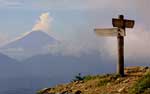
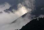
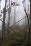
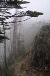
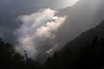
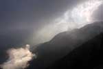
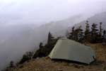
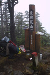
After miraculously getting a week off work in September, I decided to use it for the hike that I had been planning for over a year. My original plan was to climb Mt. Kumotori from Tamboyama village in Yamanashi prefecture across to Saitama prefecture and all the way home to Kamikawa. But that would mean not climbing another mountain that I wanted to visit before leaving the country - Mt. Kobushige. In the end I decided to walk from Mt. Kumotori on Yamanashi/Tokyo/Saitama border to Mt. Kobushige on Yamanashi/Saitama/Nagano border. Both mountains are on 100 best mountains list in Japan which means great views, but also huge crowds. In 4 days I covered about 50 km on the trail that followed the mountain range on the border of Saitama and Yamanashi prefectures right in the heart of Chichiibu-Okutama National Park. On Sunday, Sep. 19, Ewa and Dena drove me to the head of the trail. There was a sign saying "WATCH OUT FOR BEARS" that made Ewa panic a bit, but I found it hard to believe that there could be bears in Central Japan. Later the year 2004 proved to be the bear attack year in Japan. It was late in the afternoon and I said 'Goodbye' quickly. I wanted to reach a good camping spot before the nightfall. There was a shrine marked on my map about an hour from the start of the trail and I planned to spend the night there, but after passing 2 uninhabited buildings and getting halfway to Mt. Kumotori I decided to keep walking until it was dark. The trail was very easy, rising very gently. That afternoon I met only 1 person - an older man going down towards the village. There was nothing different about him except for his luggage. It was and old-style Japanese system of carrying heavy loads over the mountains. It was made of 2 poles or planks connected at the bottom and it was a frame to which cargo was usually fastened. The man had 2 beer cases (2 TWOFOURS or 2 FLATS or whatever you call it at home) and a plastic bag filled with something on top. He asked if I was going to the top and when I answered 'Yes' and he said that he only asked because he thought it was kind of late and continued walking down. When it was almost completely dark, I reached the first mountain hut and continued walking with my flashlight for another few hundred metres until I reached another shrine just below the summit of Mt. Nanatsuishi. Right before reaching the shrine I startled what I thought was a monkey. It was no more than 10 metres from me and because it was dark I only heard it gallop a bit further down the path where behind some thick bushes it gave a few high-pitched sounds. At that time I was sure it was a monkey even though monkeys always travel in groups, but deer never came to my mind until the last day when I heard the same high-pitched sound and was told that it was a deer. The altitude was already about 1700 metres. The air was clear and the crescent moon was bright. I lied in my tent trying to listen to the forest sounds and fell asleep to the cry of an owl sitting somewhere in a tree nearby. It felt good to be away from all the noise and the hot, humid Japanese summer air. In the morning I noticed that the entire ground was covered with some kind of larvae that looked like a cross between a centipede and a maggot. It looked like a maggot, but walked like a centipede. The creatures were beige and almost see-through and moved pointlessly in every direction. There were so many of them that I couldn't move without stepping on them. After a rich breakfast of bread with bananas, jam and peanut butter and some instant egg soup I was back on the trail. It was a bit chilly and foggy. The summit of Mt. Nanatsuishi was just around the corner from the shrine. The clouds were still hanging low covering all the mountains around and it was windy on the summit. Between Mt. Nanatsuishi and Mt. Kumotori I passed by the second mountain hut and a helicopter landing area (in case Koizumi decides to visit) and soon I was on the last steep climb to the summit of Mt. Kumotori at 2017m. On top it was windy and cold, but the views were great. For the first time that day I could see Mt. Fuji in the distance and the mountain stayed with me until the afternoon when it was covered by the clouds. On the other side the trail started descending very rapidly and I remember feeling glad to be going down on that side and not up. After about 20 minutes the path came to a flat terrain and it stayed like that for most of the day. I saw the last group of people that day before reaching Mt. Kobushige. It was great. While still on the summit, I thought for a moment about walking towards Chichibu and Kamikawa across Mt. Ryogami, but in the end I took the trail leading to Mt. Kobushige and Nagano prefecture. For the next 3 hours the trail stayed mostly flat leading through a beautiful forest on the southern side of the Cchichibu-Oku mountain range (I think that's the name). The weather was great. It was sunny and warm. If there was wind it was on the other side. I passed Mitsuyama, Hhiryuyama and reached Shyougen Pass where I originally planned to camp, but it was still early and I continued to Mt. Kasatori. On the way there I passed Mt. Karamatsubi/Karamatsuo and Mt. Kokkai/Kurokai before I found a good camping spot below the summit of Mt. Kasatori right on the path next to a picnic table. I ate breakfast listening to deer walking on dry leaves scattered on the side of the mountain near me. They were making the high-pitched sounds like the night before and were looking for a bite to eat. I ate supper and went to bed. Third day on the trail. The col itself was really beautiful. It was covered with grass and it looked like a giant horse saddle with 2 slopes to the N and S and beautiful views to the W and E. It was an intersection of 2 different trails, and mine was leading up one of the mountains. The trail zigzagged up for about 40 min. and it was very steep. On the way up, every few minutes, I looked back on the col. It looked beautiful, but the climb was painful. 40 min. later it became less steep. It stayed all the time in the forest, but from time to time I had a nice view on the Mitomi village lying down the valley on the Yamanashi side. The climb from the col took me to the summit of Mt. Tsubakura and after a while the trail crossed to the Saitama side and lead on the northern side of the mountain for some time. The forest on this side created a dreamy atmosphere with everything covered in green moss. The standing big and small trees, the lying rotten logs, small stones and huge boulders, everything was green. It looked like a scene from a movie. I was getting closer to my destination passing other, lower summits like Mt. Kore/Fururei at 2112m and Mt. Suishou at 2158 before arriving at Karisaka mountain hut where I could get water. The hut was located below the Karisaka Pass on the Saitama side and it was hidden from the winds coming up the slopes from Yamanashi prefecture, but when I reached the pass, it was windy and cold. The clouds rose very quickly and for the next 4 hours I walked in fog trying to cover every single part of my body from the cold winds. From Karisaka Pass the trail started going up again to the top of Mt. Karisakarei and then it was mostly flat until I reached the foot of Higashihafu mountain where the slope became almost vertical, but fortunately not for very long. The good thing was that it wasn't raining, but I could smell the rain in the air. I couldn't see any animals. There weren't even any birds except for one in the woods that looked like a wild turkey. It was huge and brown and it flapped its wings a few times totally ignoring me. I stopped and watched it for sometime, but it was too dark to take any photos. I climbed the almost vertical slope of Mt. Higashihafu and had a rest. Mt. Hafu has 2 peaks - Higashihafu at 2108m and Nishihafu at 2317m. The trail between these 2 peaks leads right across huge, flat rocks piled up on top of each other at various angles to the ground right on top of the ridge. When the rocks ended, the path entered a forest for a few minutes until it reached a steep descent leading down more of those flat rocks to an unmanned mountain hut. The hut was located at an altitude about 200m lower than Mt. Nishihafu in the col between Nishihafu and Kobushigedake mountains.�@As I was going down towards the hut, it began to rain and when I finally reached the building it was pouring down. It was windy and cold outside. Inside wasn't much better. There were no windows so I had to open one of the 2 doors to let the light in letting the strong wind get inside. There was a stove in the middle, but no wood and everything outside was soaked. I began to worry that the rain and short thunderstorm was gonna keep me there for the night, but after 20 minutes everything went back to normal. From the hut the trail began ascending to the summit of Kobushigedake. At first it lead through a forest and after about 30 minutes I reached a sandy island with no trees and beautiful views. There were also giant boulders scattered around of interesting shapes. From this sandy island the trail followed a path carved in the ground by the rain water running down the slope. The entire trail between the mountain hut and the top of Mt. Kobushige lead through a forest except for the small sandy island with great views. The mountain hut, located right below the summit of Mt. Kobushige, as I expected, was full of noisy people and I didn�ft feel like stopping there. I kept walking to the top passing crowds of people, some young, some old and some already drunk. From the summit I couldn't see much. The clouds were moving fast and the sun showed its face for a few seconds at a time. I wanted to camp there, but there was no flat area big enough for a tent. Luckily, when clouds cleared for a few seconds I was able to see down the slope from where I came and I noticed another sandy island passed the mountain hut, among the trees and right at the edge of a cliff. It looked like a perfect spot for a tent. It was getting late and I decided to climb down, set up a camp and eat something warm. The spot was near enough to the hut that I had to do everything very quietly not to let the "mountain man" know about my presence. There was no way I was gonna pay for a spot in the forest and I'm sure he would've charged me if he knew I was there. The clouds never fully disappeared towards the evening, but as it got later the sun kept showing its face more and more. I took some pictures, ate nice supper and went to bed. The wind stopped blowing and it looked like the weather was gonna be much better the next day. But it wasn't meant to be and by midnight the wind was so strong that I just waited for it to pick up the tent and make it fly down the cliff. I saw myself lying somewhere down the slope, unable to move and dying of hypothermia. It was freezing and I seriously thought about getting up and moving the tent away from the edge and near the trees to hide from the wind, but my laziness was much stronger than that plus I was too cold too move. When I got up at about 6 the next day, my tent was still there, but so was the wind. It hadn't stopped and I was still too cold too move, but there was no choice. I couldn't just lie there all day, so I packed everything in a record time, filled the water bottles at the hut and took off. As i expected the day before, the mountain man asked me where I camped and when I told him that it was far away from his place, he looked at me suspiciously, but didn't say anything. There was another guy who left the hut in the same direction. After the first seconds I decided to get in front of him as far as possible because I couldn't stand the sound of a bell tied to his backpack. It's a Japanese thing and almost every person has a stupid bell like that to scare off bears. Never mind that together with bears all other animals hide long before they can be seen, but it's Japan. It seems like here all that's important is to get from A to B and nothing in-between matters. To escape the guy and his stupid bell, I almost ran down the slope towards the mountain hut that I escaped to from the rain the previous day. I stopped there for breakfast and when I was getting up to leave, he had just arrived. He passed me a few more times later on whenever I was taking a rest always announcing his approach with the bell and the last time I saw him was right before the Karisaka Pass. From there I went down to Karisaka hut and I guess he went either towards the Mitomi village, down the slope or towards Mt. Kumotori. All the way from Mt. Kobushige to the Karisaka Pass it was windy and cold. Things changed though on Saitama side. The clouds were below and the sun was shining on this side of the mountains and I finally got a break from the cold winds. At the hut I ate the rest of the food and had a short chat with the mountain man. I heard more of the familiar high-pitched sound that I heard on the first and the second day. I learned that the sound came from a deer that was hanging out near the hut that morning and that the altitude was much too high for the monkeys. The hut was at the altitude of about 2000m and monkeys prefer to stay lower where more food is available and it's much warmer. The "mountain man" also told me about bear sightings on Saitama side where my trail lead, but he didn't know any details. The hike from the hut to the Mameyaki bridge in Otaki village right before Karisaka tunnel was very pleasant. It was downhill from there and it took me almost 3 hours. I reached the head of the trail on this side and noticed a familiar sign that I saw 4 days ago - 'WATCH OUT FOR BEARS'. Unfortunately, apart from the deer and some birds it seemed like the forest was empty. When I was waiting for Ewa and Dena at some kind of centre's parking lot, two tour buses arrived and people flooded the place for about 10 minutes (Japanese way). In that time they all managed to walk around looking at everything there was to look at including a dirty, smelly foreigner who just came out of the forest after 4 days. |
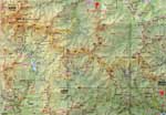 see the map
|