|

Distance: 40 km
Weather: Drizzle
Ueno village is located almost on the border of Gunma and Nagano prefectures. The village was just an ordinary place
like any other mountain villages in Japan until 1985. That year the biggest air disaster that shook the world took
place on a side of one of the local mountains - Mt. Takamagahara. Over 500 people died in the crash and miraculously 4 survived.
It's about 60 km from the town Kamikawa where we moved in November '02.
Kamikawa is located at the foot of the mountains that extend west to Nagano prefecture and beyond. Nagano border
is only 60 km away. Across the river from our building is Onishi town in Gunma prefectureand there begins
the road that goes all the way to Saku town or Kitaaiki village, both on the eastern border of Nagano and Gunma
prefectures. The road (R462) that is actually an extension of the roads connecting Kodama and Onishi and Fujioka and
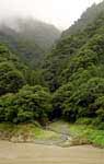
Onishi follows Kanna river for about 50 km. It is a beautiful ride on a serpentine road through the backcountry
of Japan, the sleepy mountain villages where time moves very slowly.
It begins with a beautiful gorge in Onishi town. From there it continues in the valley with mountains on both sides.
A few kilometers passed Onishi is a big dam and a lake behind it. When I rode to Uenomura during the typhoon season
in August, the dam was opened after
a week of heavy rains, releasing huge amounts of water. This is where the biggest climb between Onishi and the major
climb on the Nagano-Gunma border is. Passed the tunnel is a descent and after that it's just up and down. The road
gradually raises, but it happens very slowly and hard to notice.
The towns on the way are Mamba and Kanna. In Manba, there is a very old looking shrine with a wooden gate (torii).
It's a place worth visiting. Also here begin many hiking trails leading to the HigashiMikabo and NishiMikabo
mountains located to the right side of the road.
Passed Kanna town, R462 hits R299 that leads straight to Nagano or to the left across Kanna river and the mountains
to Chichibu town. The road to the left leads to an archeological spot where dinosaur prints were discovered a few
years back.
It also leads to some good hiking trails in the area. One of them is the trail to the top of Mt. Ryogami from where
Mt. Fuji can be seen. There are so many walking trails here that it's possible to reach Chichibu-Tama National Park
and beyond that. The trails stay usually empty because most of the hikers prefer the mountains
on the other side in Nagano leaving these paths a pleasure to walk.
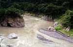
The route that goes straight towards Nagano runs right by a giant rock lying right in the middle of the river. It's
a sacred place marked with a little shrine by the road. The rock is called Maruiwa and the area near it is a great
place to camp. The river here is very shallow, but there are many rocks of a different size scattered along the shores
and by the bigger ones the water is usually deep enough to cool off in the summer.
Further up the road is a cave with a falling apart straw roof shack in front of it. The cave was man made and from
what we were able to find out, was used by a man to grow silkworms 1000 or 2000 years ago. It was all discovered
by a professor from Tokyo University. This is what we were told by a lady near the cave. The cave is open.
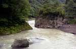
My destination was Jumoku falls on Kanna river 40 km from Kamikawa. It's a nice place to camp, but a little noisy
because of the falls. It also looks like a good fishing spot. The water here is deep enough to swim, but freezing
cold.
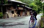
There is a very nice mountain village a little passed the falls. The first road to the left leads to it. It's an
interesting place to see. Rural Japan is so much more interesting than cities.
The road continues towards Nagano prefecture. It passes through a nice village of Ueno. There are many limestone
caves in the local mountains.
Near the mountain range that borders Nagano and Gunma, the road splits. The road to the right leads to Jukoku pass,
but it has been closed because of a landslide and the one to the right leads across the mountains through
Budo pass to Kitaaiki village or to a detour that leads to Jukoku pass. The detour isn't used by many cars and is
very quiet.
It is also in this area where the plane crash spot is and it can be reached on foot by a nice trail following a stream.
It takes about 1 hour to reach the crash site. On the site there are graves and other memorial places erected for
the victims.
Generally, the entire route is a very nice ride. There are cars as almost anywhere in Japan, but
not as many as on the main roads and they didn't bother
me that much. Besides the scenery is simply amazing and it takes your mind off of
other things. The scenery is even nicer riding or driving back towards Onishi rather than
away from it. It's because it's slightly downhill almost all the way.
There is a lot of nice spots to camp along the river and there are many public toilets along the road.
Back to RIDES
|